Re: Re: Region graphics
By: Janis Kracht to mark lewis on Tue Mar 17 2020 21:28:34
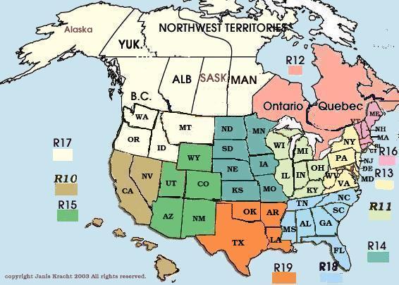
That page uses html mapping by coordinates on the page within each
region
my map also used the map and area tags... i still haven't gone
digging for it... the picture i use, though, was more geo
oriented with colors for land types...
That's neat :)
i forget where i got it from but it was likely one of the gov sites... the file
i started with wasn't graphical at all but there was an easy conversion to turn
it into a jpg (IIRC) which resulted in the final picture... i'll see if i can dig it out today and get it back online with the rest of my old fido stuff... it'll need some reworking for the new server but that shouldn't be too hard...
i never got around to overlaying the state outlines on it... i
laid out the coords manually... it was quite the job to do and
trying to find software to do it was a real huge monstrous
PITA... especially since i didn't want to pay for something
that would be used only for this one task...
Understand that one :) I used gimp to draw graphic, then I used
kompozer to add the map points.. all free linux tools. Works
for me <grin>
i don't think i had much going on linux at the time i did my graphic... i think
i was working mainly on winwhatever... it could have been that i found a tool for use on OS/2 but i really don't recall since it has been so long ago... the server was definitely apache running on OS/2 Warp 3 Connect, though LUL
[time passes]
it was a gif that i turned the geo data into... if my rsync backups are accurate, this was back in 1998 or 2002... the one i did the map with was the whole globe and i have images for
-rw-rw-rw- 1 myuser mygroup 53068 Sep 6 2002 AFRICA.gif
-rw-rw-rw- 1 myuser mygroup 37246 Sep 6 2002 ASIA.gif
-rw-rw-rw- 1 myuser mygroup 35574 Sep 6 2002 AUSTRALIA.gif
-rw-rw-rw- 1 myuser mygroup 29420 Sep 6 2002 EUROPE.gif
-rw-rw-rw- 1 myuser mygroup 2347 Mar 8 1998 fido1.gif
-rw-rw-rw- 1 myuser mygroup 77620 Sep 6 2002 globe.gif
-rw-rw-rw- 1 myuser mygroup 28514 Sep 6 2002 NAMERICA.gif
-rw-rw-rw- 1 myuser mygroup 15716 Sep 6 2002 SAMERICA.gif
but apparently i never got around to mapping the regions on them... i had also had the idea to make a graphic for each region and map the nets onto them but there's not enough information publically available and easily attainable for that level of detail so i just went with using a table for the links after the globe... not to mention that things could change pretty quickly and i really didn't feel like having to update the maps when that happened... especially since i didn't have a decent tool to use for the task...
here's a link to a 2002 version of my fidonet page that is archived on the wayback machine... it has the mapped graphic i've been speaking of...
https://web.archive.org/web/20040906010727/http://www.wpusa.dynip.com/fidonet/index.html
turns out it is the whole globe instead of just the US that i mapped...
the wayback machine seems to have missed getting other image files for those fidonet pages, too... at least the one for zone 1 doesn't show the image and the page source doesn't show any of the map and area tags...
i'll see if i can get them back online today... i might even see about using that kompozer for doing the mapping thing on my zone images ;)
)\/(ark
--- SBBSecho 3.10-Linux
* Origin: SouthEast Star Mail HUB - SESTAR (1:3634/12)